


beal tarn

lablaquiere
User
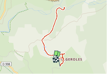

Length
5.3 km

Max alt
1255 m

Uphill gradient
130 m
Km-Effort
7.1 km

Min alt
1170 m

Downhill gradient
148 m
Boucle
No
Creation date :
2022-07-15 12:01:13.855
Updated on :
2022-07-15 15:16:58.079
1h36
Difficulty : Medium

FREE GPS app for hiking
 SityTrail
IGN / Geographical institutes
SityTrail Plus
The world is yours!
About
Trail Walking of 5.3 km to be discovered at Occitania, Lozère, Pont de Montvert - Sud Mont Lozère. This trail is proposed by lablaquiere.
Positioning
Country:
France
Region :
Occitania
Department/Province :
Lozère
Municipality :
Pont de Montvert - Sud Mont Lozère
Location:
Le Pont-de-Montvert
Start:(Dec)
Start:(UTM)
562715 ; 4912101 (31T) N.
Comments